The 4.25-acre central open space at Candeur Kukatpally, Kukatpally, Hyderabad
Site plan

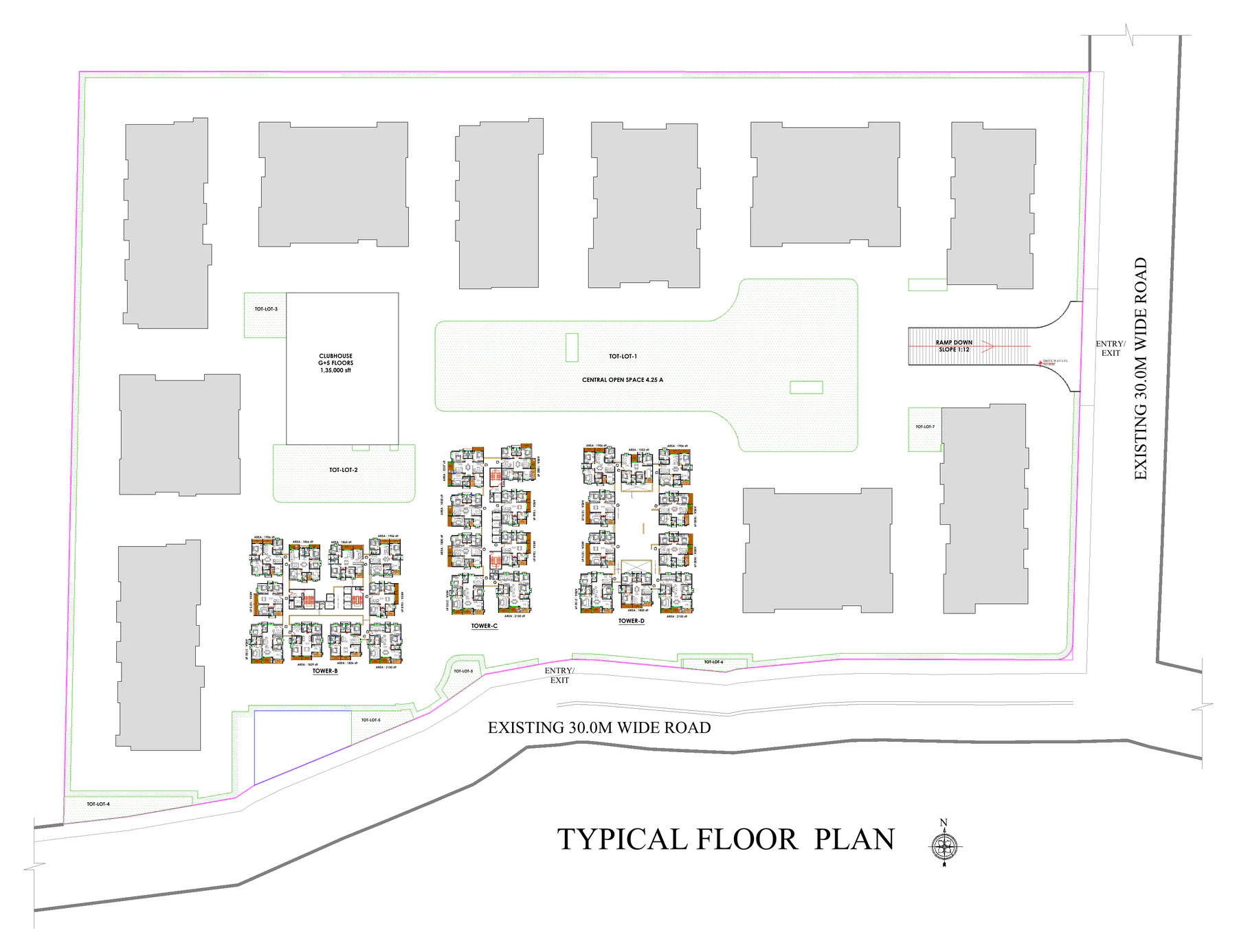
Candeur Kukatpally Master Plan - thirteen towers, one connected green core.

At a glance

How 20 acres is allocated

The defining number in this master plan is 4.25 acres of central open space - more than a fifth of the total site, held open at the centre. That land could have carried more towers. In a market where Kukatpally land transacts at an implied Rs 10 to Rs 13 crore per acre, holding 4.25 acres open represents a very large deliberate cost, and it is the clearest signal in the plan of the tier the project is being built to. For another Hyderabad planning reference, Hallmark Altus helps keep attention on density, circulation, landscape depth, and the way residents will move through the community.

Candeur Kukatpally master plan provisions
ElementProvision
Total land area20 acres
Residential towers13
Central open space4.25 acres
Clubhouse1,35,000 sq ft, G+5 floors
Tot-lots7 (TOT-LOT-1 to TOT-LOT-7)
Site frontageTwo existing 30 m (100 ft) roads - east and south
EntriesTwo - east and south
Basement accessRamp at 1:12 from the eastern entry
Configurations2.5 BHK, 3 BHK, Premium 3 BHK
Size range1,552 - 2,207 sq ft
The drawing

Candeur Kukatpally Master Plan - thirteen towers around a green spine

Towers occupy the northern edge, the eastern and western flanks and the southern corners, leaving the middle band of the site open. The consequence is that a large share of apartments look inward onto the park rather than at the facade of the next tower - which at high-rise density is the single biggest determinant of how open a community feels.

The sheet draws ten of the towers as building footprints and renders Towers B, C and D at full detail in their site positions, immediately south of the central open space. Ten footprints plus three detailed plates totals the 13 towers stated in the project documentation.

Site master plan of Candeur Kukatpally showing 13 towers around the 4.25-acre central open space, Hyderabad
The site master plan: 13 towers ringing the 4.25-acre central open space, with the G+5 clubhouse on its western flank and seven tot-lots distributed across the site.
Land use

Where the twenty acres go

Shares below are read off the drawing and are approximate. What the arithmetic makes clear is that the open space is not a residual - it is the largest single allocation in the plan after the towers themselves.

Approximate land-use split across the 20-acre site
Land useApproximate share
Central open space4.25 acres (about 21%)
Tower footprintsAbout 20 - 24%
Clubhouse and amenityAbout 5 - 7%
Roads, driveways and rampsAbout 14 - 17%
Distributed tot-lots and pocket landscapeAbout 8 - 10%
Services and utilitiesAbout 5 - 6%
Setbacks and perimeter landscapeBalance

Connected, not fragmented

4.25 acres distributed as strips between towers would be setback with grass on it. Held as one connected corridor it becomes a park with a length you can walk - the difference between landscape you look at and landscape you use.

Air movement

A continuous open corridor through the middle of a dense site lets air move across it rather than stagnating in sealed courtyards. On a Hyderabad site with long hot months, that is a comfort factor with real value.

Generous separation

With only 13 towers on 20 acres and a fifth of the site held open, inter-tower spacing is generous relative to the norm for high-rise Hyderabad projects. That is what the density arithmetic buys.

The clubhouse

Six levels in a single envelope

The clubhouse runs to 1,35,000 sq ft across G+5 floors, sited on the western flank of the central open space. A G+5 clubhouse is a substantial building in its own right, and the vertical format is the right answer on a 20-acre site: stacking six levels rather than spreading a single-storey pavilion keeps the ground plane available for the park it opens onto.

A programme of this size can carry the multipurpose hall, banquet and celebration spaces, indoor games arena, gymnasium, co-working provision, wellness facilities and community rooms without any of them competing for the same floor - which is exactly what happens when a 13-tower community is served by a 40,000 sq ft clubhouse.

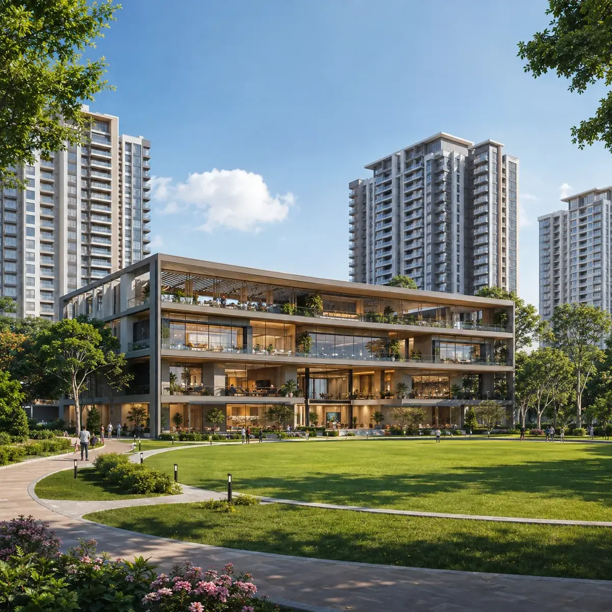
The G+5, 1,35,000 sq ft clubhouse at Candeur Kukatpally, Kukatpally, Hyderabad
1,35,000 sq ft across G+5 - more than double the 62,000 sq ft clubhouse at Candeur's completed Crescent tower.
Circulation

Roads, entries and how the site is served

The site is bounded by two existing 30-metre-wide (100 ft) roads - one along the eastern boundary and one along the southern. These are existing roads, not proposed ones, which removes a common category of pre-launch risk.

Two independent entries

Separate entry and exit points on the eastern and southern roads. In a locality as dense as Kukatpally, residents are not funnelled through a single junction at peak hours, and a blockage on one road does not seal the community.

A 1:12 basement ramp

The eastern entry carries a ramp down at 1:12 to basement parking - a comfortable, code-compliant slope, gentler than the 1:8 or 1:10 that tighter sites are forced into and easier on low-clearance vehicles.

Traffic-free core

A driveway network connects the entries to tower drop-offs and basement access, with the central open space kept clear of through-traffic so the park functions as a pedestrian zone.

Below-grade parking

Putting parking below grade is what allows the surface plane to carry the park, the seven tot-lots and the landscape network. Surface parking would have consumed a substantial share of the open space the plan is built around.

Water and waste

Underground sump capacity pumped to overhead tanks with pressure zoning across tower heights, plus an on-site STP returning treated water to landscape irrigation and flushing.

Power and storm water

Substation and transformer yard, ring-main distribution to tower cores, generator backup for common areas and essential loads, and graded drainage sized for peak monsoon intensity.

Wider context

One parcel inside a 190-acre estate

Candeur Kukatpally occupies one parcel within GOCL Corporation's Kukatpally estate - approximately 264.5 acres being monetised under a Rs 3,402 crore programme. The estate's own phase master plan subdivides the land into 18 lettered plots, served by five proposed master plan roads including a 100 ft road on the north-west edge, with a dedicated lake buffer retained along the north-east. Total plotted extent across that phase runs to roughly 190 acres gross and 165 acres net.

Two things follow for a buyer. The lake adjacency is structurally protected: a retained buffer in the landowner's own master plan is a stronger guarantee than a marketing claim about lake views. And the neighbourhood is planned rather than accidental - the parcels around this site will be developed under a single estate master plan with coordinated road infrastructure. Godrej Properties' bid for a nearby 7.825-acre KPHB parcel indicates the calibre of development the belt is attracting.

The distinction to hold onto is that the product is the 20-acre project. The 190-acre estate is the context it sits in, not the scheme being sold.

Estate programme

GOCL's Kukatpally monetisation, board-approved and publicly reported.

Rs 3,402 Cr

Estate extent

Approximately 264.5 acres across the wider Kukatpally landholding.

264.5 acres

Phase plots

Eighteen lettered plots under a single coordinated master plan.

18 plots

This project

The 20-acre parcel being sold. The estate is context, not the scheme.

20 acres

Candeur Kukatpally Master Plan - Frequently Asked Questions

What does the Candeur Kukatpally master plan show?

Thirteen residential towers on 20 acres arranged around a 4.25-acre central open space, a G+5 clubhouse of 1,35,000 sq ft on the western flank of that open space, seven tot-lots distributed across the site, dual frontage on two existing 30-metre roads, and two entries - one of which carries a 1:12 ramp down to basement parking.

How much open space does the master plan hold?

4.25 acres of central open space, more than a fifth of the total site, held as a single connected corridor running east to west through the middle rather than distributed as leftover setback. Seven separate tot-lots sit on top of that, with the largest, TOT-LOT-1, inside the central open space.

Why are only ten towers visible on the drawing?

The sheet draws ten towers as building footprints and renders Towers B, C and D at full detail in their site positions, immediately south of the central open space. Ten footprints plus three detailed plates totals the 13 towers stated in the developer's project documentation.

How big is the clubhouse and why is it stacked?

1,35,000 sq ft across G+5 floors. Stacking six levels rather than spreading a single-storey pavilion keeps the ground plane available for the park the clubhouse opens onto. For context, Candeur Crescent at Serilingampally carries 62,000 sq ft and Candeur Eternia at Bachupally runs twin clubhouses totalling roughly 68,000 to 73,000 sq ft.

How do vehicles enter and park?

Two entries, one on the eastern 30-metre road and one on the southern. The eastern entry carries a ramp down at 1:12 to basement parking - a comfortable, code-compliant gradient, gentler than the 1:8 or 1:10 that tighter sites are forced into. The central open space is kept free of through-traffic so the park functions as a pedestrian zone.

Why are there seven tot-lots instead of one big play area?

On a 20-acre site with 13 towers, a single central play area serves the towers next to it and effectively does not exist for the towers at the far end. Seven distributed zones mean every tower cluster has one within a short walk, and a parent can supervise from close by rather than making an expedition of it.

What has the master plan not yet fixed?

Three items remain open and will be settled at RERA registration: the floor count, which the developer records as high-rise but unspecified; the total unit count, not officially disclosed; and the phasing order in which the 13 towers are built. These are ordinary pre-launch gaps, but the RERA declaration - not marketing material - is the binding statement of what will be built.